Hadrian’s Wall

Contents [show]
- Location Description
- Project Location
- Historical Context
- Approximate Year of Completion
- Duration of construction
- Project description
- Construction details/observations
- Other significant comments
- Sources and references
- Project Id
Location Description
Across Northern England, Bowness-on Solway to Wallsend, 55.0242° N, 2.2925° W
Project Location
54.95554005461726LOL-1.746826171875
Historical Context
Hadrian, the emperor of Rome, ordered to have the wall built to mark the northern frontier of the Roman empire, separating the Roman territory from the barbarians to the north. Hadrian's biographer wrote "(Hadrian) was the first to build a wall 80 miles long to separate the Romans from the barbarians." (Wikipedia)
Approximate Year of Completion
130 AD ("Hadrian's Wall Gallery." BBC News. BBC, n.d. Web. 10 Nov. 2014)
Duration of construction
122 AD- 130 AD ("Hadrian's Wall Gallery." BBC News. BBC, n.d. Web. 10 Nov. 2014)
Project description
“Hadrian's Wall was 80 Roman miles or 117.5 km (73.0 mi) long; its width and height were dependent on the construction materials that were available nearby. East of the River Irthing, the wall was made from squared stone and measured 3 metres (9.8 feet) wide and 5 to 6 metres (16 to 20 feet) high, while west of the river the wall was made from turf and measured 6 metres (20 feet) wide and 3.5 metres (11 feet) high. The initial plan called for a ditch and wall with 80 small gated milecastle fortlets, one placed every Roman mile, holding a few dozen troops each, and pairs of evenly spaced intermediate turrets used for observation and signalling. However, very few milecastles are actually situated at exact Roman mile divisions; they can be up to 200 yards east or west because of landscape features or to improve signalling to the Stanegate forts to the south.” The milecastles and turrets were of three different designs, depending on which Roman legion built them – inscriptions of the Second, Sixth, and Twentieth Legions, show that all were involved in the construction. All were about 493 metres (539 yards) apart and measured 14.02 square metres (150.91 square feet) internally.("Hadrian's Wall." Wikipedia. Wikimedia Foundation, 11 Oct. 2014. Web. 09 Nov. 2014.) Here is a map of the wall running across England (Contours).

Construction details/observations
“Hadrian's Wall makes use of locally-available materials. Running for forty-five miles from the east, the Wall was built of stone. The stone wall had two outer faces of dressed stone, containing a centre of rubble. The remaining thirty-one miles of the Wall in the west was built of turf. The turf wall, constructed from turf blocks, was built either from the prepared ground or upon a bed of cobbles. Rubble and mortar were used to fill the centre of the stone walls. Both stone and turf portions of Hadrian's Wall are pictured below. The Wall was built from locally-quarried stone; Roman stone-masons have left inscriptions in the stones which describe the location of these quarries.” ("Hadrian's Wall Gallery." BBC News. BBC, n.d. Web. 10 Nov. 2014). The stone walls themselves were well-built, with a rubble core between facings of dressed stone set in lime mortar.Construction was divided into lengths of about 5 miles (8.0 km). One group of each legion would excavate the foundations and build the milecastles and turrets and then other cohorts would follow with the wall construction.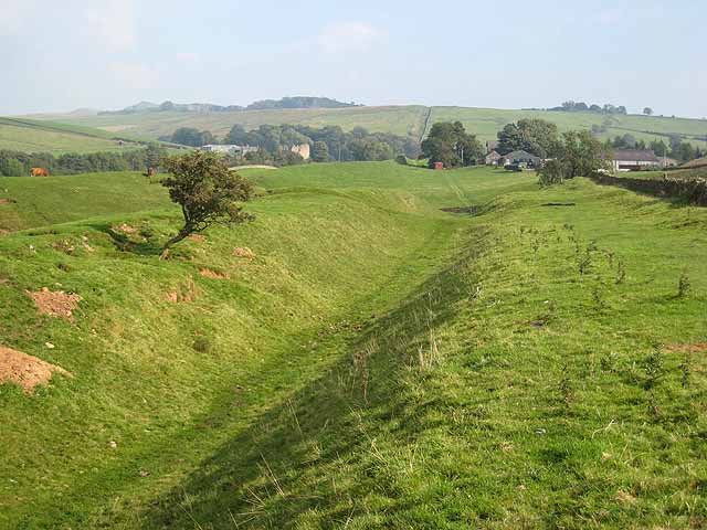

Other significant comments
To the south of the Wall are a road, the Military Way, and another ditch, flanked by banks called the Vallum. The Vallum was built after the Wall and was an earthwork construction running the length of the frontier from the Tyne to the Solway. It defined the rear of the military zone, controlling movement of people into the military area. This can be seen in the picture below. Once its construction was finished, it is thought to have been covered in plaster and then white-washed, its shining surface able to reflect the sunlight and be visible for miles around. (Wikipedia)
Sources and references
(2014). “Hadrian’s Wall.” Wikimedia Foundation, < http://en.wikipedia.org/wiki/Hadrian%27s_Wall> (April 30, 2015)
(2014). "Hadrian's Wall Gallery." BBC, <http://www.bbc.co.uk/history/ancient/romans/hadrian_gallery.shtml > (April 30, 2015)
Project Id
MRS-02-14
Selected Topics
Want to read more like this?

Antonine Wall
Feb, 03, 2015 | EducationLocation Description Running through the Central Belt of Scotland, 55.967 N, 4.067 W Project Locatio...

Section of iconic wall in Winchester, UK, collapses
Jul, 28, 2021 | NewsA section of a historic wall located in Winchester, UK collapsed on July 6, 2021. Winchester is a...

Wall of Jericho
Jan, 31, 2015 | EducationLocation Description 6 miles west of the Jordan River and 10 miles north-northwest of the north end...

Millo
Jan, 25, 2015 | EducationLocation Description Jerusalem Project Location 31.763202209896072LOL35.219078063964844 Historical C...

Citadel of Jerusalem
Jan, 15, 2015 | EducationLocation Description 31°46'34.87"N/ 35°13'42.29"E Project Location 31.776318699595294LOL35.228476524...

Catastrophic Collapse of a Log-Building Lodge: A Forensic Analysis for Civil Engineers
May, 28, 2024 | NewsIn the high alpine environment of the Rocky Mountains, a vacation resort faced an unexpected disast...

Storm rips off the wall of a 12th floor apartment in Kuala Lumpur, Malaysia
May, 19, 2023 | NewsThe wall of a 12th floor apartment in Kuala Lumpur was ripped off during a thunderstorm on Friday,...

Walls at Alesia
Feb, 03, 2015 | EducationLocation Description City of Alesia, now modern day Alise-Sainte-Reine, France 47.537 N, 4.500 E Pro...
Building walls with demolition waste - the poetry of Cyclopean concrete
Sep, 16, 2022 | NewsAncient cyclopean walls were built by overlapping raw stones, supported one on the other, without t...
Trending

Calculation example - Three Point Resection

Gauss's Area Calculation Formula

The history of the Golden Gate Bridge

Kallanai Dam (Grand Anicut)

Ancient Greek Cisterns

Calculation example – The intersection method

Calculation example – Elevation calculation and grade along a profile vertical curve
